Thursday, July 29, 2010

Little Lakes Valley for Dawn, Tenaya Lake for Sunset


Tenaya Lake Pollen Lines, originally uploaded by Jeff Sullivan.

I'm going on so many hikes, it's getting hard for me to follow me! I know, I'll go on my blog and see where I've been... Doh!

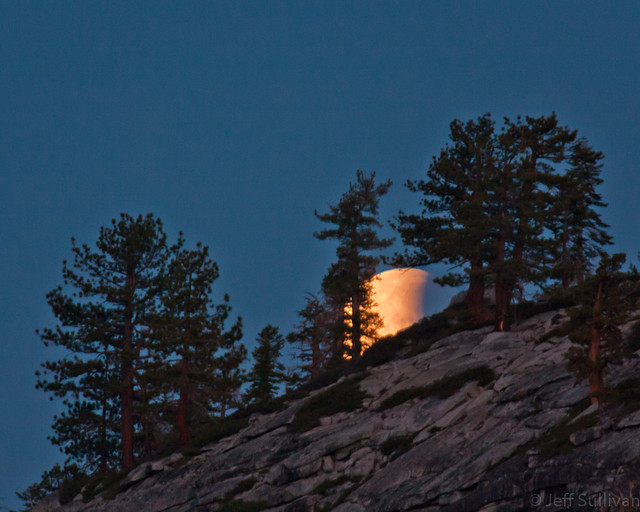
OK, so painstakingly reconstructing my movement by photo timestamps it now comes back to me... after Minaret Lake I shot Rock Creek/Little Lakes Valley for dawn, then made my way back to Mammoth to talk to Ranger Mike about destinations. He had photos from all over on his PC, recommended a bunch of places, and issued me a permit to hike to Gardisky Lake up near Saddlebag so I could shoot back towards Conness Peak at sunrise. It didn't turn out that way, but I'm getting ahead of myself... let me start with Rock Creek.


The Mosquito Flat trailhead at the end of the Rock Creek road has a hikers' walk-in camp at the end... all you need is a wilderness permit to stay there. That puts you right there to do a short hike before dawn to get up the lakes as the alpen glow starts to light up the peaks. It's a lot easier to pull this off in the Fall, when the sun comes up later! Anyway, you can start a few hundred yards up the trail (and some bushwhacking to the south) at Long Lake, but I usually go a mile or so up to the first lake on the trail There's an even better lake another mile up, but who wants to get up that early? Either way plan to arrive roughly 30 minutes before the published sunrise time, as the sun will stike these tall peaks 10-15 minutes before sunrise. For the more subtle alpenglow before the direct sunlight, allow yourself that additional 15 minutes. Make sure you also make allownaces for your fitness level and your degree of acclimation to the elevation around 9000 feet (another reason to stay overnight nearby... it makes the hiking easier). One really nice feature about Little Lakes Valley is that the mos tinteresting mountains to shoto are far enough to the south that you're not shooting directly away from the sun, and your shadow doesn't get in your shots after the sun rises. You can shoot your way up the valley for hours.

To make a long story short, one brunch, coffee / Internet stop and wilderness permit later I was off to Yosemite. The weather didn't seem interesting enough for a great show at Cathedral Lakes that night, so I headed over to Tenaya Lake.

The west end of the lake offers a variety of interesting foregrounds and a nice view of the granite ridges over the east end, so I headed there. The wind died right on schedule as the sun dropped and the light warmed. I crossed the outlet creek to shoot from the crushed granite beaches, but evan with heavy repellent the mosquitos were too persistent, so I retreated with a few nice shots already captured.

Wednesday, July 28, 2010

In Search of Cathedral Peak Reflections

I started the day up near Saddlebag Lake to shoot a sunrise timelapse sequence on a nearby ridge. Then I hiked in to explore the lakes up by the old mining camp of Bennettville, hiking out in time to move to Tuolumne Meadows for a Cathedral Lakes sunset hike.

I arrived at Cathedral Lakes early enough to scout out both lakes. I arrived at Lower Cathedral Lake to find a enthusiastic welcoming committee of ravenous, probably disease-ridden, blood-sucking bugs. The few surviving human visitors to this lake were beating a hasty +retreat, doing what will be forever etched in my mind as the "Cathedral Lake dance," an awkward combination of jogging, arm-waving, stream-hopping and loud expletives.


Spotting a reflection of Cathedral Peak accompanied by an unreal, seemingly metallic cobalt rending of sky blue in the inky tea-colored waters of a nearby stagnant pool, I decided to make some use of the rock-like camera gear which for the past 3.5 miles had only served as ballast in my daypack. Aware of the risk of picking up some rare and exotic plague from the parasites spawned in this pool of decaying primordial goo, I blithely pulled out a small vial of insect repellent to keep the little pests at bay. The repellent was 100% DEET, which I knew was roughly 3.4 times stronger than the maximum effective concentration of 29% as determined by Consumer Reports. It's not possible to repel mosquitos any better than 100%, and I might grow new organs and evolve into some awkward new life form from excessive toxic chemical exposure, but perhaps I could keep the little buggers 3.4 times farther away and reduce my odds of becoming a curiousity at the Centers for Disease Control.

The chemical haze only served to confuse the little creatures, which continued to bump into my arms and legs, sing in my ears, dicover patches of unprotected flesh around my eyes, and (the last straw) congregate on my camera and in front of the lens.

I made quick work of the mosquito pond, checked the map for a possible direct route to the upper lake, and struck out to find a game trail that would lead me over the polished granite cliffs between me and my next destination.

I arrived at the upper lake to find mosquitos slightly lower in numbers, but no less annoying, so I kept moving farther up the westward granite slope to get farther and farther from their home. Eventually I ended up on a large and more or less flat rock way up the slope, killing time before sunset by killing mosquitos, and counting the ones resting on my camera and tripod (up to 12).

The wind picked up however, so I had to move down to the lake to increase my odds of finding some calm water to get the reflection that I had gone up there for. Fortunately the wind calmed down for a few minutes right when I needed it to, so I was able to catch a few good shots before making the long, dark hike back out to the trailhead at Tuolumne Meadows.


Second Try at Minaret Lake

After getting shut out on my attempt to make a visit to this lake realtively easy from the adjacent canyon, I returned a few days later to make the long, hot 7.5 mile hike up from the bottom, via Devil's Postpile National Monument. This time I camped in the monument ot be able to drive my own vehicle in, which greatly simplified logistics (and enabled me to use a bear box to safely store food away form my vehicle, an option which was lacking on the prior week's trip when the ranger station advised me to park at Mammoth Mountian and take the shuttle in).

It would be a 15 mile round trip, so I budgeted two nights in case I might want a layover day to go explore nearby lakes.


In the end however I decided that I wanted to make sure tha I got to Yosemite and Cathedral Lakes more, so I hiked back out the daya after arriving, and headed back to the Tioga Pass/Saddlebag Lake area to catch sunrise and get ina hike to the old mining camp of Bennettville before making the Cathedral Lake hike in time for sunset.

Quick Overnight to Twenty Lakes Basin

The subtraction of Minaret Lake from my John Muir Wilderness trip left me with an extra day on my hands. On the exit day from Devil's Postpile National Monument I headed up to Rock Creek to catch Little Lakes Valley at dawn while the peaks had snow on them, then I headed up to Saddlebag Lake at 10,000 feet to catch the boat taxi down the lake to the Twenty Lakes Basin. The mosquitos were thick and aggressive, as was becoming a theme for the season. I had just enough time to catch a couple of Brook Trout or dinner, make camp, and prepare for an early sunrise (sleep).


By dawn I made my way up to Conness Lakes, and I worked my way to one of the upper lakes to catch one with snow and ice still on it. Descend, break camp, hike out, catch the boat taxi, and off to the next location!

The Trail Succumbs to Snow

Descending from Garnet lake to Shadow Lake, the mosquitos were becoming more numerous and persistent, so it was a fast trip. Taking a right turn up the canyon, I completed the roughly 5 mile trip to Ediza Lake. There was no access to the northside of the lake and there still quite a bit of snow on the north-facing and east-facing slopes, so campsites were difficult to come by. The wind was strong, but the mosquitos were stronger. I had a brief moment of relative calm winds and water to catch some reflected light on the far shore, then I retreated to the safety of the tent to prepare for dawn, which fortunately arrived calm and clear. It wasn't cold enough for the snow to re-freeze solid, and I hadn't carried crampons or gaitors on this trip, so I decided not to traverse the snow and pass up past Iceberg Lake, and to put off a visit to Minaret Lake.


Gem on the John Muir Trail

Next on the itinerary was Garnet Lake. Following the John Muir Trail from Thousand Island Lake to Garnet Lake was an easy two miles and change, so I had time to shoot a few pictures at Ruby Lake along the way, and to catch some Brook Trout for dinner once I arrived. Fortuantely a guide-led tour of hikers arrived to help finish dinner so I could run off to catch sunset.


It wasn't clear whether or not sunset color would punch through the clouds, but in the nick of time the sun came through and the skies really lit up. I had a few short minutes to run around and see how many compositions I could capture. There were far more than I could do justice to, but I knew that I was bound to have a couple of keepers.

I returned to camp to enjoy some nice "blue hour" light, with a faint echo of sunset light from the distant horizon still painting the bottoms of the clouds.

For sunrise I moved further west along the northern shore of the lake, enjoying the changing light on Banner Peak and on the lake's islands.

Friday, July 16, 2010

Starting Backpacking Season with a Bang


First Morning Dawn, originally uploaded by Jeff Sullivan.

I was determined this Summer to do a fair amount of backpacking to reach some of the most scenic portions of the High Sierra. Although trail accessibility was delayed somewhat by a healthy Winter, I was determined to get up to a few lakes before the snow on the surrounding peaks was entirely gone. For the first trip I decided to do a loop out of Devil's Postpile National Monument starting on July 10, from Agnew Meadows to Thousand Island Lake, Garnet Lake, Ediza Lake, and possibly cross-country over to Minaret Lake. Much of the trip would be in the vicinity of 10,000 feet in elevation, so I built an extra acclimation day into the schedule.

I could only get a wilderness permit to enter on the Pacific Crest Trail, so I'd start off with an eight mile day rising a couple of thousand feet. That portion of the trial was exposed, hot, my packing wasn't as Spartan as it should have been, and I was carrying five days of food, so it was a long haul. Obtaining the wilderness permit, taking the requirted bus shuttle into the park, and the hike itself led me to arrive jsut before the sun went down. There was wind on the lake, so I'd have to wait until morning for the best conditions and light. Fortunately the dawn conditions didn't disappoint, with the snow-clad Banner Peak reflecting in the still waters of the lake, an angular cloud providing additional light-catching capability and interest.


During the day I navigated cross-country up to a nearby ridge to catch a view over Sullivan Lake and down to the June Lakes Loop. I ruturned in time to catch alpenglow in the sky over a small iceberg.


Fortunately the skies that night were clear and no moon was visible, so the starts were incredible: bright and endless in number. The lake was calm, so the Milky Way reflected clearly in its waters. With a start like this, I couldn't wait to see what the next days would bring!

Wednesday, July 07, 2010

Fireworks Photography on the July 4th Weekend, 2010


Fireworks Over Lake Tahoe, originally uploaded by Jeff Sullivan.

Even landscape photographers take a day or two off from time to time, but that doesn't mean that we can't still take our cameras along! On Saturday I enjoyed fireworks and a BBQ at a friend's house overlooking Napa Valley, then headed up to Lake Tahoe the next night to enjoy fireworks there as well. Before the fireworks began, I spent some time exploring the prolific lupine growing along the shoreline.  Tahoe is a great place to catch fireworks, since there are many displays around the lake, and some towns avoid the competition from other displays by scheduling theirs for July 3, so you can actually pursue fireworks 2 nights in a row!

There used to be a great display at Squaw Valley resort, but in recent years that has been suspended due to increased fire danger in the recent drought years.


Tuesday, July 06, 2010

Twisted Trunks: The World's Oldest Living Things

As my kids and I were flying around the Eastern Sierra last week, it came up that they hadn't visited the Ancient Bristlecone Pine Forest. It's an amazing place, and given the heat of the Owens Valley that week, an elevation of 10,000+ seemed like an even more attractive place to be.


In addition to being interesting for their exotic shapes, bristlecone pine trees are very long-lived. One nicknamed "Methuselah" was measured via a coring tool to be 4789 years old in 1957, so it should turn 4842 this year. In 1964 another specimen "Prometheus" was determined to be over 4000 years old, but the coring tool broke, so permission was given to cut it down. It turned out to be at least 4844 years old when it was killed.
We reached the Patriarch Grove after sunset, but we still had enough light to get some shots.


My daughter found this unique "wooden arch" etched into one of the tough old trunks.


The next morning we woke up in BLM's Grandview Campground at an elevation of roughly 9000 feet, and we found a scorpion outside the tent... right next to our shoes!

Dawn of Opportunity


Dawn of Opportunity, originally uploaded by Jeff Sullivan.

My memory gets a bit hazy on the details as I dragged myself through a sequence of relatively sleepless days, but eventually I woke up early enough to shoot a timelapse sequence of the sun rising over the Bodie Hills off towards the horizon.


The Bodie Hills are among 14 areas being considered for National Monument status. Many of them are rarely-used areas of BLM (Bureau of Land Management) land, which enables you to go use them to your heart's content with minimal restriction. National Monument status could close them to maost use, except in developed campgrounds. You'll then be charged for the "improvements" (the sound of adjacent generators and drunken rednecks blasting country western music... sorry, just my recent experience in campgrounds during the past 2 weeks...), they'll probably charge National Monument/National Park $20-25 fees instead of the BLM's mroe typical $2-3 (when there's a fee at all), and the added attention will ensure that the lands get far more trampelled and whatever endangered wildlife allegedly needs "protection" there will be more challenged and endangered than ever before.

Don't worry though, there's a group of people in Washington who believe that their sole purpose in life is to obstruct anything that the President does (never mind that meeting in the middle is often the healthiest approach for citizens of the country), so eleven lawmakers have introduced a bill to block the administration's ability to create monuments. I'm clearly no knee-jerk supporter of converting these lands to monuments, but I have huge reservations about blocking the ability to create them when appropriate (and when that symbolic move won't actually cause worse problems). Isn't the two-party system supposed to result in rational, middle-of-the-road compromises which actually make sense? Why do we seem to have a recent rise in extreme polarization and rampant dysfunction? Is it simply a case of "because it works" (to make politicians bribe-rich), combined with a gradual erosion of adequate controls to punish people when there's excess?

We didn't venture into the Bodie Hills on this trip though. Instead we stuck along highway 395, heading up to Big Meadow near the town of Bridgeport to meet with Tom Lowe of www.Timescapes.org. We found a nice patch of iris growing in an irrigated pasture (replacing the ubiquitous sagebrush in the area), we explored some side roads where I shot some "sundog" rainbows in the sky, and we watched some large young hawks sitting in a nest on a power pole, while "Mama hawk" circled overhead, watching us.
We finished the day back in the iris field, with Tom filming my daughter walking in the warm light of the setting sun.

Foresta Lupine at Dusk


Foresta Lupine at Dusk, originally uploaded by Jeff Sullivan.

After photographing the lunar eclipse over Half Dome from Olmstead Point, I drove down to Yosemite Valley with the intention of staying there for the night and shooting "moonbows", lunar rainbows from the light of the full moon shining in the spray of Yosemite Valley's massive waterfalls. In spite of getting in line roughly 45 minutes before that morning's same-day campsite release at 8:30am, Yosemite holds back too few campsites to meet demend and I was unable to get a campsite that morning. Although my name was then placed on another list for reservation cancellations which would be released at 3, again I showed up and the supply dramatically failed to meet the demand (Yosemite removed a campground in 2001 following a flood, and failed to replace the lost sites or develop others, so sites are reserved months in advance and anyone who can't plan that far in advance is simply out of luck).

You've seen the weather that I encounter though... I often get lucky. Just as I was about to leave the unappeased crowd milliong about the campground reservation office, a woman walked up to me and offered to sell me her campsite for that night. She had bought it on Craigslist from soneone else who couldn't use it!

To make a long story short, my kids took me on a tour of the "Indian Caves", we returned and had the campsite set up by 6pm or so, had completed dinner by shortly after 7, but the sky was blue and clear, and I was too tired to go out for an alpenglow-only sunset. I went to the tent to take a nap, setting my alarm to get up late at night to go shoot moonbows. The alarm went off, I was too tired to get up, and I went back to sleep.

The next day packed up camp, took care of some adminstrative things via wi-fi in Curry Village, and headed up towards Foresta to see how the lupine were doing.


First stop was Cascade Creek, which is in shade this time of day, to capture long exposures. Next we explored the lupine fields at Foresta during a relatively colorless sunset.
Without no campsites available in Yosemite Valley, we aimed for the Eastern Sierra, where at least the Forest Service (under the Department of Agriculture, not the dysfunctional Department of the Interior)) provides a far better match between campsite demand and availability (and they allow siteless primitive camping as an option so site availability is not an issue).
Along the way the moon rose, so I paused to capture the moon rising behind trees on the ridges. I also paused to photograph frogs singing in my favorite pond near Tioga Pass.

Late, late, late at night, I had survived my campsite shortage and bureaucrat-imposed exile far from Yosemite Valley, and I had set up camp by 2:30am in the Eastern Sierra.

Aggressive Black Bears in the Sierra Nevada

Mama Bear #31 Mama Bear #31, originally uploaded by Jeff Sullivan.

Typically black bears in California's Sierra Nevada are considered relatively harmless. Yosemite National park for years encouraged campers to chase them out of their campsites, as if they were large, furry stray dogs. The legality of bear hunting in adjacent national forests encouraged bears to teach each generation of cubs to be wary of humans.

The death of a bear by stoning at the hands of a boy scout troop in recent years encouraged Yosemite to retract their policy of having campers aggressively defend their campsites from bears. Expanding designation of wilderness areas has further decreased human aggression towards bears, resulting in the doubling of bear populations since the 1980s, and greater competition for food. A greater number of much bolder bears pursuing a limited food supply has resulted in an absurd numbers of vehicle and home break-ins by bears every year.

The management practices in Yosemite National Park alone have resulted in roughly 1000 vehicle break-ins by bears per year there since the late 1990s. Yosemite management focuses on the positive and notes that bear incidents are down, but as you check into campgrounds in Yosemite Valley you can still see that season's scorecard, with the numbers passing the 600 and 700 mark every Fall. Yosemite officials blame visitors, urging them to remove food from their vehicles, but even after decades of having this problem Yosemite has failed to place an adequate number of metal "bear boxes", and they've even where a few have been provided such as Curry Village, management has failed to adequately distribute them around the parking lots to encourage and facilitate their use, revealing the problem as being as much due to egregious mismanagement as anything else.

There have also been a number of attacks on humans by bears, including one last week in a campground in El Dorado County. The count was approximately a doxen from 1980-2003, but there were only 3 in the 10 years from 1983-1993, seven from 1993-1996, and with attacks in 2007, 2008 , 2009 and 2010, the rate remains troubling. Bear attacks also occur in other states such as New Mexico and Colorado, and the Sierra Club is now recommending that everyone who enters bear country carry pepper spray designed for the long distance shots needed to repel bears. Bear spray has been proven to be more effectve than guns. Protect yourself.

Lunar Eclipse Moonset from Olmsted Point

Lunar Eclipse Moonset by Olmsted Point
Using the free program The Photographer's Ephemeris to predict the path of the moon during the lunar eclipse as starting over Half Dome and ending a few degrees to the North on the horizon, I set my camera up to capture a timelapse sequence of the event. It will take a significant amount of time and effort to produce the video, but I did take a couple of shots around sunrise that I can share.

Following Sierra Clouds Over Tioga Pass

After pursuing a large storm parked over the Eastern end of the Mono Basin for a while, I turned my attention towards getting up into Yosemite National Park to shoot the lunar eclipse late that night. Fortunately upon arriving in the Tioga Pass area I was treated to some nice broken clouds that would make shots taken long he way more distinctive.


My first stop was alongside Ellery Lake, where the light was fantastic but challenging, since cameras do not "see" in the same way that we do. Our eyes change exposure constantlya s we look around a scene, and there is no way that we can fully reflect both the "levelling" of exposures that our eyes perform and yet retain the full range of brightness and contrast that we also perceive in the overall view. In this case I simply chose to use Adobe Lightroom's Fill Light to make the shadows more accessible, and to decrease Brightness to prevent highlights from being blown out. A few quick shots at Ellery, and I was back to my quest to get over the pass.

Tioga Pass sits at an elevation of 9943 feet. There are some ponds in the area that can provide some nice reflections, but the wind was just energetic enough to encourage me to pass them by this time. A couple of miles down the road however there's a larger pond which sits lower and is protected by trees, so the reflection of the couds, Mt. Dana, and surrounding forest was excellent.
There was still snow in places among the trees and the water was high, so there were some unique shooting opportunities to be found. However, there were three cars stopped already and 8 or 9 photographers who seemed firmly entrenched in some of the best shooting positions, so I carried my camera and a couple of lenses so I could work around them. That turned out to be an advantage in some cases as I captured some unique perspectives that I might not have taken the time to try had my camera been attached to a tripod.
I continued my exploration past Tuolumne Meadows. Tenaya Lake was too rough from wind to be particularly photogenic, but I found a small snowmelt pond which had a nice reflection of a ridge bathed in warm evening light. There were few clouds to catch sunset light however, so I returned to Tuolumne Meadows where some coulds along the Sierra crest could catch the light.

Storm Clouds Over The Mono Basin

On this afternoon I was eager to head over Tioga Pass to Tuolumne Meadows in Yosemite National Park, but as I drove north from Bishop in the Eastern Sierra and entered the Mon Basin, there were some nice storm clouds building over Mono Lake. That's too nice of a photo opportunity to pass up, so I turned on highwya 120 towards Mono Lake's South Tufa access.


When I arrived at the South Tufa turnoff, it was clear that the majority of the clouds were well East of the South Tufa site, so I took a right fork in the dirt road to head out to Navy Beach, where I could place sand tufa formations in the foreground of my shots.
After taking a variety of shots I resumed my course towards Yosemite, but upon reaching the highway 395/120 intersection just South of the town of Lee Vining, a rainbow appeared over Mono Lake. If I could reach the Old Marina access point just north of town, I could adjust my position to place the rainbow over the tufa offshore there, and zoom in to get a ncie composition and to make the rainbow major elements in the photo. The rainbow came and went for a few moments, and then was gone. Fortunately I had arrived just in time to capture a frame or two with the image that I had anticipated.